

E-Biking & Sensitive areas data
How might we use data to encourage e-bikers to move respectfully in sensitive alpine areas?
The impact of e-biking on the environment
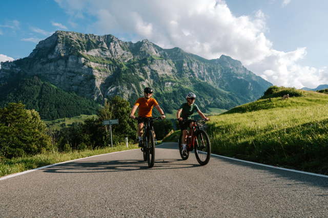
E-biking has gained significant popularity as a sustainable and healthy mode of transport, especially in mountain areas like the Alps. While biking long, sometimes steep, scenic routes used to be accessible only to well-trained people, e-biking increases the accessibility for more locals and visitors.
More and more hotels and bike shops offer e-bikes for rent, and organized e-biking tours are an increasingly popular activity among tourists. Despite its rising popularity, e-biking can negatively impact the environment, especially in sensitive areas such as alpine meadows and high-altitude ecosystems. The stress of e-biking can result in soil erosion, vegetation damage, and wildlife disturbance.
Therefore, it is essential to develop innovative solutions to reduce the stress of e-biking in these sensitive areas while maintaining the popularity of e-biking among tourists and locals.
E-biking in Vorarlberg
The Western region of Vorarlberg has extensive routes that can be enjoyed with e-bikes (read more here). Routes include both alpine areas, such as the Bregenzerwald, Montafon, and Kleinwalsertal, as well as natural areas around rivers and lakes, such as Lake Constance and the Rhine River delta. Vorarlberg’s development of a region-wide mountain bike network (including e-bikes) is currently regulated (read more here). Each new trail opening is discussed at a systemic level, considering different possible uses of the area, such as hiking, nature conservation, hunting, etc Planning is carried out in consultation with landowners and trail operators (usually the municipalities), and it may involve eventual additional road construction measures. Once the trail has been planned and prepared, it gets included in the region’s geographic information system (VOGIS). Several incentives and funding exist for the maintenance of mountain biking trails. The funding covers the installation of pasture grates to preserve agricultural lands, among others. However, mountain bikers are personally responsible for their conduct. For this reason, education about appropriate biking behavior is an important aspect to consider to preserve nature, as well as ensure enjoyment and safety.
The challenge
This challenge aims to develop innovative solutions that leverage data to reduce the stress of e-biking in sensitive areas in the Alps. We use the term sensitive areas to refer to places that require special care and attention due to their ecological significance or high human activity. In the context of our e-biking challenge that includes natural reservers (protected areas with delicate ecosystems and endangered species) and highly Frequented Places (popular locations with high foot traffic and cultural significance).
To tackle the challenge you are expected to use various data sources such as satellite imagery, GPS data, and environmental data to develop Artificial Intelligence enabled solutions that can help to:
– Identify sensitive areas that are vulnerable to e-biking stress
– Predict the level of stress that e-biking can cause in these areas
– Develop alternative routes or modify existing routes to reduce the stress on these areas
– Educate e-bikers about the impact of their activity on the environment and how to minimize it
Participants can use any data analysis or machine learning tools and techniques to develop their solutions. Consider how the use of AI could contribute to solve the issues around e-biking and sensitive ecosystem protection. The initial solutions should be developed having Vorarlberg as a test region, yet they should be replicable in other regions, and have a measurable impact on reducing the stress of e-biking in sensitive areas in the Alps. The solution can address one of the points mentioned above or more than one. Note that solutions might not be exclusive for e-biking, but also be applied to biking as well as hiking. To identify the flow of e-bikers, new methods need to be invented as current data-gathering methods cannot differentiate between e-bikes and bikes.
Among possible solutions, you can consider using crowdsourced data to create live “traffic maps”; involve experienced bikers in scouting new trail possibilities; create territorial visualizations as a decision-making tool for trail planning, etc. Be creative in identifying data sources and combining data in unique ways to derive actionable insights to support e-biking’s growth while preserving regional landscapes. Ideally, your idea integrates with existing navigation apps and devices to avoid additional information sources. Think about the opportunities of data ecosystems for bringing different data sources together to allow for new applications and services. You might also include weather data for your solutionprovided by MetGIS.
Collaboration incentive
The team with the best idea is invited on a trip to Vorarlberg to refine their idea in collaboration with tourism stakeholders. During the trip, winners will have the opportunity to share their ideas and receive expert guidance to accelerate their projects’ progress. You are invited to explore one region in Vorarlberg to experience the rich cultural heritage and natural beauty.
*The fine print: The collaboration incentive is non-exchangeable, non-transferable, and is not redeemable for cash or other prizes. Travel costs to Vorarlberg are covered up to EUR 160 per participant (in case of a journey of more than 50 km from the participant’s residence).
Resources & Data
Resources
Freizeitradverkehr Vorarlberg Study
Masterplan Freizeitrad
Radfahren und Mountainbiken in und um die Alpenstadt Bludenz
E-Bike Ladestationen
Data
Verwall – Naturvielfalt (helpful for Sonnenkopf destination)
Verwall – Biotop Data (helpful for Sonnenkopf destination)
Geo-Informationen: Vorarlberg Atlas & Maps
Digitize the planet
Weather Data is shared by MetGIS
Conservation areas and Dos & Don’ts for Pfänder, Karren & Sonnenkopf
Sign up to tackle the challenge or learn more.
?? E-Biking & Daten zu Naturschutzgebieten
Wie können wir Daten nutzen, um ein respektvolles E-Bike Fahrverhalten in sensiblen Gebieten zu fördern?
Die Auswirkungen von E-Biken auf die Umwelt
E-Biken hat als gesundes und nachhaltiges Transportmittel vor allem in Bergregionen wie den Alpen stark an Popularität gewonnen. Während das Radfahren auf langen, manchmal steilen, landschaftlich reizvollen Strecken früher nur gut trainierten Menschen vorbehalten war, ist es mit dem E-Bike nun für viel mehr Einheimische und Tourist:innen möglich. Die westliche Region Vorarlbergs verfügt über ausgedehnte Routen, die mit dem E-Bike befahren werden können (mehr dazu hier). Die Routen umfassen sowohl alpine Gebiete wie den Bregenzerwald, das Montafon und das Kleinwalsertal als auch Naturgebiete rund um Flüsse und Seen wie den Bodensee und das Rheindelta. Mittlerweile bieten viele Hotels und Fahrradhändler E-Bikes zum Verleih an, und organisierte E-Bike-Touren werden immer stärker von Tourist:innen nachgefragt. Neben der zunehmenden Beliebtheit, kann das E-Biken allerdings auch die Umwelt schädigen, insbesondere in sensiblen Gebieten wie Alpweiden und hochgelegenen Ökosystemen. Die Belastung durch E-Biken kann zu Bodenerosion, Vegetationsschäden und Störungen der Tierwelt führen. Daher ist es wichtig, innovative Lösungen zu entwickeln, um die Belastung durch das E-Biken in diesen sensiblen Gebieten zu verringern und gleichzeitig die Beliebtheit des E-Bikens bei Tourist:innen und Einheimischen zu erhalten.
E-Biken in Vorarlberg
Die Entwicklung eines flächendeckenden Mountainbike-Netzes in Vorarlberg (einschließlich E-Bikes) ist derzeit geregelt (lesen Sie mehr dazu hier). Jede neue Streckeneröffnung wird auf einer systemischen Ebene diskutiert, wobei verschiedene Nutzungsmöglichkeiten des Gebiets wie Wandern, Naturschutz, Jagd usw. berücksichtigt werden. Die Planung erfolgt in Absprache mit den Grundeigentümer:innen und den Streckenbetreiber:innen (in der Regel die Gemeinden) und kann eventuell zusätzliche Straßenbaumaßnahmen beinhalten. Sobald der Weg geplant und vorbereitet ist, wird er in das geografische Informationssystem der Region (VOGIS) aufgenommen. Für die Instandhaltung von Mountainbikestrecken gibt es verschiedene Anreize und Fördermittel. So wird unter anderem das Anlegen von Weidegittern zur Erhaltung landwirtschaftlicher Flächen gefördert. Die Mountainbiker:innen sind jedoch selbst für ihr Verhalten verantwortlich. Aus diesem Grund ist die Aufklärung über das richtige Verhalten beim E-Biken ein wichtiger Aspekt, um die Natur zu erhalten sowie Spaß und Sicherheit zu gewährleisten.
Die Herausforderung
Ziel dieses Hackathons ist es, innovative Lösungen zu entwickeln, die Daten nutzen, um die Belastung durch E-Bikes in sensiblen Gebieten in den Alpen zu reduzieren. Von den Teilnehmer:innen wird erwartet, dass sie verschiedene Datenquellen wie Satellitenbilder, GPS-Daten und Umweltdaten nutzen, um Lösungen zu entwickeln, die folgendes beitragen können:
– Identifizierung sensibler Gebiete, die anfällig für Belastung durch E-Bikes sind
– Vorhersage des Ausmaßes der Belastung, die das E-Biken in diesen Gebieten verursachen kann
– Entwicklung alternativer Routen oder Änderung bestehender Routen, um die Belastung dieser Gebiete zu verringern
– Aufklärung von E-Biker:innen über die Auswirkungen ihrer Aktivität auf die Umwelt und wie sie diese minimieren können
Die Teilnehmer:innen können beliebige Datenanalyse- oder maschinelle Lernwerkzeuge und -techniken verwenden, um ihre Lösungen zu entwickeln. Die ersten Lösungen sollten mit Vorarlberg als Testregion entwickelt werden, sie sollten jedoch in anderen Regionen replizierbar sein und eine messbare Auswirkung auf die Verringerung der Belastung durch E-Bikes in sensiblen Gebieten in den Alpen haben. Die Lösung kann einen der oben genannten Punkte oder mehrere ansprechen.
Zu den möglichen Lösungen gehören die Verwendung von Crowdsourcing-Daten zur Erstellung von Live-“Verkehrskarten”, die Einbeziehung erfahrener Biker:innen in die Erkundung neuer Streckenmöglichkeiten, die Erstellung von Gebietsvisualisierungen, die das Gebiet als Entscheidungshilfe für die Streckenplanung abbilden, usw. Seien Sie kreativ bei der Identifizierung von Datenquellen und der Kombination von Daten auf einzigartige Weise, um verwertbare Erkenntnisse zu gewinnen, die das Wachstum des E-Bike-Verkehrs fördern und gleichzeitig die regionalen Landschaften erhalten.